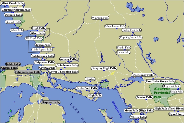
Ontario is a big place and is divided up into different regions by different organizations. The area depicted on this map roughly corresponds with the area Ontario Parks describes as the "Near North". It also includes a chunk of what they describe as "Northeastern Ontario". Algoma District and Sudbury District make up most of the depicted area. Temiskiming, Nipissing, and Parry Sound Districts make up the eastern edge. The upper left corner is part of Thunder Bay district.
The Canadian Shield sits right on top of this part of Ontario. This rocky landscape is responsible for many waterfalls. Most of this region is lightly populated and many of these waterfalls are in remote locations far from roads.
I have not visited the north-eastern part of this region. The 25m Helen Falls is in Lady Evelyn-Smooth Water Provincial Park. According to canoeists the nearby Centre Falls is even more impressive. There are apparently several other waterfalls in the area.
According to the Geographical Names of Canada there are a few falls in that empty spot between Helen's Falls and Lake Superior, but I have not learned any specific about the waterfalls in this area. Wawaitin Falls is or was a 30 meter high waterfall. The name shows up in lists of Canadian waterfalls but I think it might have been obliterated by a dam. There have been a lot of dams built in Ontario and many waterfalls have been lost as a result.
For a comprehensive list of Ontario's waterfalls see Mark Harris's Waterfalls of Ontario.
This page has been accessed
27742 times.
Last Modified:
Tuesday, 25-Mar-2008 16:01:42 MDT.


